

Laser Scanning
Laser scanners produce a monochromatic intelligible beam of light which bounces off the object with the time between laser light hitting surface and its return being used to interpret depth data and unique identifiers.
Lasers are the Device

LiDAR Scanning
Light Detection and Ranging
LiDAR scanners measure the range and structure of the environment using penetrating laser light pulses. LiDAR is the technology whereas Lasers are the devices used to emit the pulses.
LiDAR is the Technology / Process
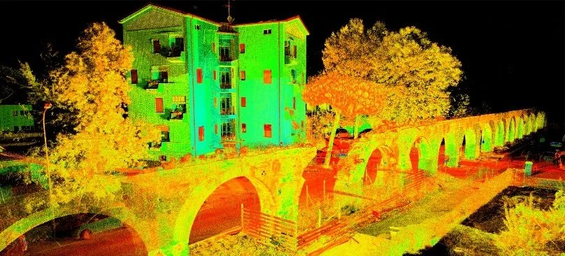
Point Clouds
The term ‘Point Cloud’ is used as an overarching term is used to define coordinate data, the source of this data can vary but will typically fall under one of the following categories of capture.

Point clouds essentially mark the verticies and points of collosion on an object captured from a 3D scanning process, the more dense the point cloud the more detail is being generated, point cloud data in its raw form is not the same as a 3D mesh as the name suggests it being a cloud of points (vertices) means there are gaps between these points which must be interpreted via software to be able to convert this into a 3D mesh that can be used by other programs such as for CAD and VFX. This data can be very large and difficult to work with in its raw state which is why this data is typically converted into Mesh formats as this allows for optimisation processes and erroneous data to be removed.
Advantages
High levels of accuracy
Ability to capture small to medium-scale objects and spaces effectively
Relatively fast and instant compared to some alternatives
Not impacted by infra-red from sun / other sources, Longer range than Infra-red
Disadvantages
High cost to entry - Equipment, Workstations, and Software
Requires significant processing and power
Has issues with certain surfaces (see challenges with 3D scanning section)
Most Common Use cases:
Conservation and preservation of objects and spaces, Manufacturing / Production and troubleshooting, Surveying, High fidelity asset generation